Monday 30 January 2012

Kingsmill Viaduct & Newstead Abbey


This week we had a complete change of scenery and went over to the dark side and headed over to Nottinghamshire to visit what we understand to be the site of the country’s oldest railway viaduct which cut across the bottom end of Kingsmill Reservoir. The reservoir was necessary to supply water all year round for the increasing number of water powered mills and in 1837 the 4th Duke of Portland flooded 72 acres of his land to ensure this.

It all started in 1813 when a railway line was proposed between Mansfield and the canal at Pinxton.  The son of William Jessop, Josias was appointed as the engineer and the viaduct was to have 3 arches and be called the Portland Bridge (Viaduct). The first one was constructed from timber but was replaced by stone in 1899. This viaduct is also the 4th oldest railway bridge in the country. The original use for the railway was to transport the cotton up from the barges on the Cromford canal to the mills in the area and in particular the Hermitage Cotton Mill. The area is now known as the Hermitage Local Nature Reserve. 
Kingsmill Viaduct

The Hermitage Nature Reserve through the arch.
Keystone in the Kingsmill Viaduct
Geoff getting a bit close to this swan.
A surprise was just waiting less than 50 metres away from the viaduct when we discovered the Hermitage Nature Reserve established in 2004 complete with Heronry. Iv’e never seen a Heronry before and was very impressed. There was about 5 or 6 birds there already sitting in the trees waiting for the breeding season to begin. The nests are huge and we were told by a local angler there are usually around 20 birds in the spring, so we’ll be heading back around end of March to have a look.
Hermitage Local Nature Reserve

Grey Heron

Part of the Heronry
 We had a chat to a couple of photographers who told us all about the Herons and there is also a kingfisher resides in the reserve. The equipment they had was quite expensive just under £900 for one of the lenses. We also had a nice chat to an angler who said the place was full of carp, although there was no evidence of this in his net!!
Photographer on the right

Honest it was this big!!

The river Maun entering the nature reserve.
After we had a stroll through the reserve we decided to go and have a look at Newstead Abbey. We went to the front entrance to the park but if you take in your car there’s a charge and we were only going to be an hour, so it wasn’t worth paying (after all we are pensioners). So it was plan B, we went to the west gate and parked outside. We had our breakfast in the car and spoke to this chap walking his dog, he told us it was only 10 a minute walk to the abbey from where we were parked. We set off down this fantastic Lime tree avenue, it was straight as an arrow, passed a huge beautiful house with 3 nasty looking noisy dogs in the grounds (probably belongs to a footballer). Well 30 minutes later we arrived at the Abbey. It’s a beautiful place with a huge lake, grounds and waterfall
Lime Tree Avenue

Ike 

The Upper lake

Waterfall from the Upper Lake

Newstead Abbey
Newstead  Abbey estate was first granted to Sir John Byron following the Dissolution in 1540 and remained in the family for 10 generations the first 'Lord' Byron being created for his loyalty to the King during the Civil War. Its most famous for where the Poet Lord Byron lived at the beginning of the 19th century. The Manor house we see today  was created from the Augustinian Priory around the 12th century, sadly only the west front remains alongside the house. 

You have to pay to go into the gardens but we didn’t have time for that anyway, so it was a quick look around then back up to the car.
On the way back we passed Newstead Primary School and stopped the car to photograph these unusual bollards. what a brilliant idea!!
Bollards outside a primary school
We got back home about 12:00 after another cracking adventure.
See you next week.


Monday 23 January 2012

Nine Ladies Stone Circle & Earl Grey Tower

We had an extended party today so 2 cars were needed for the short trip up to Stanton Moor.
The route took us up through Matlock to Rowsley and then via the narrow lanes up to Stanton Lees. There were quite a lot of branches on the road blown down from the high winds which we had through the night.
Out of the car and the first stretch was all uphill, a nice steady climb to the first ruined building (a relic from the old quarrying days.)

 Just a bit further on and we came to one of the quarry faces where a lot of dates had been etched into the rock face.
This was the site of one of Europe's longest running protest camps lasting almost 10 years. At its peak there were about 80 people living there and it even had its own postcode for the 30 tree houses and mobile homes.
The protesters left voluntarily after the company stopped there plans to mine millions of tons of stone and feldspar from the two quarries.

Close up showing dates and initials on the quarry face.
The track levelled out for a short distance and we passed these unfinished millstones just lying around.

Sally with her dad 

The track was a bit muddy and soft.
After a short while the track started to climb again and the wind was really blowing a gale. Part of the path had these stone tracks set into the ground. We couldn't decide if these were a water/drainage channel or a  wheeled transport  system for horse drawn tubs.
Stone Tracks or water course?
Part of the path passed by these fantastic trees with masses of Autumn leaves still on the ground.
The wind was blowing the leaves around making a fantastic spectacle.

As we came around the hillside and at the top onto Stanton Moor Edge we passed by one of several rock formations with initials and emblems cut into there faces. These series of stones were originally known as CAT stones, this inferring there had been a battle here. The first one was The Duke of York Stone inscribed with a Y and dated 1826.

Close up of the Duke of York Stone
A little unsure of these next 2 stones, one has a G with a crown.

Geoff getting a bit to daring, especially in the high wind.


From here it was a short walk to the Earl Grey Tower. This was a shooting tower erected by William Pole Thornhill of Stanton Hall to honour Charles 2nd Earl Grey who as Whig Prime Minister from 1830 to 1834  introduced the Reform Bill in 1832.
The Earl Grey Tower on Stanton Moor Edge.
The next stone we encountered was the largest of the 4 Cat Stones and was therefor given the name Cat Stone (inscribed E.I.N. 1831).

Geoff's on the edge again!!

The Cat Stone (Cath meaning battle)

Me snapped by Sally.
A brisk walk along the edge brought us to the Gorse (Gorsedd-dau) Stone where the druids once spoke to the local people.
Our group at the Gorse Stone.
From the Gorse Stone we back tracked towards  the Earl Grey Tower and spotted Minninglow in the distance
Minninglow on the horizon.

Couldn't resist snapping this lone tree on Stanton Moor.
We went through the style at the Earl Grey Tower and took the path up to the Nine Ladies Stone Circle.
Path up to Nine Ladies
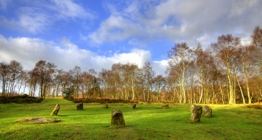
Nine Ladies Stone Circle is an early Bronze Age monument located on Stanton Moor. The circle which contains 10 stones one is flat and 9 standing stones plus a king stone which is 40 metres away. The circle was first recorded by Major Hayman Rooke in 1782. The King Stone has the name ‘Bill Stumps’ carved into it which is mentioned in The Pickwick Papers by Charles Dickens.
Legend states that nine women were dancing on the Sabbath to a fiddler – the King Stone – and were turned into stone. From at least the 1500's dancing on Sundays during church services was punishable by excommunication. During the medieval period the church tried to guide people away from paganism by linking stone circles to devil worship.

From the Nine Ladies it was all downhill but the wind was still blowing a gale.

A bit of fun with the wind and leaves.
Back at the car and a drink of coffee was a perfect end to the walk.
Sam, Brian, Geoff, Sally, Jim, Rob & Ike.
That's it for this week, a nice walk and definitely getting the cobwebs blown away.
Cheers


Sunday 15 January 2012


Had a late start today setting out about 7:50. It was a brilliant calm crisp morning with -4 degrees of frost. The trip through Chatsworth Park was hindered several times with dozens of stray sheep wandering about on the road. We parked up just about 2 miles outside Baslow just off the A621. From the car it was only a short walk across the lower reaches of Big Moor to our first target which was the Upper Barbrook Clapper Bridge.
These clapper bridges are the oldest type of bridge and they are made up from flat stone slabs being supported with uprights at each end. Some of these bridges can be 1000 years old but the local ones are thought to be between 300 and 600 years. A modern one has been put alongside this one but methinks the old'un will still be there well after the new one has gone. We were lucky to have frost and great skies for photo’s.
Gateway to the Moors

Upper Barbrook Clapper Bridge

Upper Barbrook Clapper Bridge

Rob, Ike & Jim

Geoff photographing some detail
Nice ice detail

We backtracked towards the road and along the track to Wellingtons Monument. On the way we passed on of the old Stoops. The last time we were here it was very foggy and we didn’t even see the Companion Stone that has been built about 25 metres away from the stoop.
These Companion Stones are a Lottery funded project devised and led for Arts in the Peak by Charles Monkhouse working with poets and artists of the Peak together with the Peak District National Park Authority, National Trust, Chatsworth Estates and other landowners. There are twelve of these stones placed alongside some of the 18th century guide stoops. 


Eaglestone Flat Companion Stone

18th Century guide stoop

The Eaglestone Flat Companion Stone was designed by Val Carman and the poet was David Vine.
From the Companion Stone we carried on to reach The Duke of Wellingtons Monument on Baslow Edge. The 3 metre high monument was erected in 1866 by a local man Dr Wrench to celebrate Wellingtons role in the battle of Waterloo 1815. Less than a mile away on Birchen Edge there is a monument to Admiral Lord Nelson and apparently Wellingtons Monument was to represent the army to balance Nelsons navy. There are some terrific views from this edge over towards the Chatsworth Estate.


Duke of Wellington Monument


You can see Eagle Stone from this point and we trekked off down the track in that direction. The Eagle Stone is a 6 metre high gritstone outcrop which looks nothing like an eagle. Tradition states that long ago the men of Baslow had to scale the rock to prove there fitness to prospective partners before they wed. We had breakfast here and once again we were blessed with great conditions for taking photo’s.

View from Baslow Edge

Eagle Stone rock formation

Brekki at the rock
After Brekki we legged it back to the car along the same route, we passed this tree which had its roots wrapped around a rock. On the way back to the car the clouds had rolled in and the scenes were completely different. 

Clouds starting to roll in

Tree roots around rock
A nice stroll this morning in good weather, thoroughly enjoyed it.
Cheers